Showing posts with label map. Show all posts
Handkerchief Wedding Invitation
Really cool wedding invitation!
A map on handkerchiefs featuring directions to the wedding venue.
Design + letterpressing by Kelli Anderson
Fabric printing by Spoonflower
Sewing, folding, ironing, envelope typing, stamping by Youngna
UPDATE: I was recently emailed by Kelli who sent me better pictures to post and 2 more interesting links about the project. You can view the full project here. And you can see how the invites were made here. Enjoy!
[via]
Labels:
design,
directions,
fabric,
handkerchief,
invitation,
letterpress,
map,
print,
textile,
wedding
Flowing City
A drop of water turns into a flood on this micro-city coaster. Here, the city of taipei, taiwan is re-sized into a coaster.
Condensation from the cup slowly floods the city. The water first fills up the river and slowly works its way into the narrower streets and alleys. Enjoy the view from above!
Get it here.
[via]
FedEx Campaign
A beautiful campaign by DDB Brazil for Fedex Express train, using photographs taken by photographer Manolo Moran. The idea focuses on the speed of delivery across the globe. For those of you who don't see it, the scraped paint on the walls of the building illustrated the map of the world. Genius!
[via]
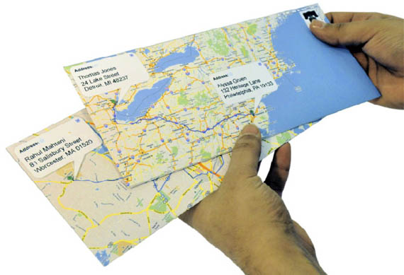
Google Maps Envelopes
Google Maps envelopes (only a concept at the moment) would let you send snail mail through a button right in gmail and print evelopes showing the route between the two addresses.
[via]
The Human Body As Subway Map
Systems of the human body depicted as a subway map. Inspired by London's Underground subway infographics. By Sam Loman.
[via]
Labels:
biology,
body,
human,
infographics,
information,
london,
map,
science,
subway,
system,
underground
Custom-Made Street Clocks

Fluid Forms lets you punch in any zip code to create a design based on a map of that location. You can completely customize the design by choosing exactly where on the map to zoom in on. Zoom all the way in on your street or zoom out to show the entire city. Street Clocks are available in a variety of colors like orange, green, blue, red, white and more.
[via]
New York City And Paris Map Cuts


A cut out map of the entire cities of New York and Paris.
Insane! That definitely required a great deal of patience and time, so its no surprise that both maps are one-of-a-kind. The NYC one is sold for $550 while the Paris one is for $250.
By Charlotte, NC-based artist Karen O'Leary's Studio K.
[via]
Stamps: Classic British Design Makers
Labels:
book,
booth,
britain,
british,
business card,
classic,
design,
fashion,
london,
makers,
map,
mini cooper,
mini skirt,
penguin,
stamps,
telephone,
underground
Subscribe to:
Posts (Atom)